
Tolland COUNTY · Farms & rural life
Coventry: farm buildings and a crossing into Mansfield
A South Street farmstead and Perkins Corner Bridge show the buildings and local routes that shaped an agricultural landscape.
Historical focus · 1914–1994
LOOK CLOSER · OPEN ANY IMAGE
The story in photographs
June 1994
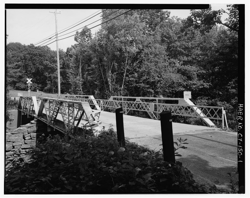
View southeast, general view of bridge within setting
View southeast, general view of bridge within setting — June 1994
Image credit & source
Wayne Fleming / Historic American Engineering Record, Library of Congress
No known restrictions on images made by the U.S. Government; images copied from other sources may be restricted. https://www.loc.gov/rr/print/res/114_habs.html
Original source · Reuse termsJune 1994
View north, south elevation
View north, south elevation — June 1994
Image credit & source
Wayne Fleming / Historic American Engineering Record, Library of Congress
No known restrictions on images made by the U.S. Government; images copied from other sources may be restricted. https://www.loc.gov/rr/print/res/114_habs.html
Original source · Reuse termsJune 1994
View southeast, north elevation
View southeast, north elevation — June 1994
Image credit & source
Wayne Fleming / Historic American Engineering Record, Library of Congress
No known restrictions on images made by the U.S. Government; images copied from other sources may be restricted. https://www.loc.gov/rr/print/res/114_habs.html
Original source · Reuse termsJune 1994
View west, traffic level from east end
View west, traffic level from east end — June 1994
Image credit & source
Wayne Fleming / Historic American Engineering Record, Library of Congress
No known restrictions on images made by the U.S. Government; images copied from other sources may be restricted. https://www.loc.gov/rr/print/res/114_habs.html
Original source · Reuse termsJune 1994
View west, substructure, east span, typical floor detail
View west, substructure, east span, typical floor detail — June 1994
Image credit & source
Wayne Fleming / Historic American Engineering Record, Library of Congress
No known restrictions on images made by the U.S. Government; images copied from other sources may be restricted. https://www.loc.gov/rr/print/res/114_habs.html
Original source · Reuse termsJune 1994
View northwest, detail of northeast portal joint, east span
View northwest, detail of northeast portal joint, east span — June 1994
Image credit & source
Wayne Fleming / Historic American Engineering Record, Library of Congress
No known restrictions on images made by the U.S. Government; images copied from other sources may be restricted. https://www.loc.gov/rr/print/res/114_habs.html
Original source · Reuse termsJune 1994
View northwest, detail of typical center upper joint
View northwest, detail of typical center upper joint — June 1994
Image credit & source
Wayne Fleming / Historic American Engineering Record, Library of Congress
No known restrictions on images made by the U.S. Government; images copied from other sources may be restricted. https://www.loc.gov/rr/print/res/114_habs.html
Original source · Reuse termsJune 1994
View northeast, detail of typical lower joint
View northeast, detail of typical lower joint — June 1994
Image credit & source
Wayne Fleming / Historic American Engineering Record, Library of Congress
No known restrictions on images made by the U.S. Government; images copied from other sources may be restricted. https://www.loc.gov/rr/print/res/114_habs.html
Original source · Reuse termsJune 1994
View northeast, detail of center pier and east abutment
View northeast, detail of center pier and east abutment — June 1994
Image credit & source
Wayne Fleming / Historic American Engineering Record, Library of Congress
No known restrictions on images made by the U.S. Government; images copied from other sources may be restricted. https://www.loc.gov/rr/print/res/114_habs.html
Original source · Reuse termsJune 1994
View west, detail of center pier
View west, detail of center pier — June 1994
Image credit & source
Wayne Fleming / Historic American Engineering Record, Library of Congress
No known restrictions on images made by the U.S. Government; images copied from other sources may be restricted. https://www.loc.gov/rr/print/res/114_habs.html
Original source · Reuse termsJune 1994
View northeast, detail of bridge bearing at southeast corner, showing welded reinforcement
View northeast, detail of bridge bearing at southeast corner, showing welded reinforcement — June 1994
Image credit & source
Wayne Fleming / Historic American Engineering Record, Library of Congress
No known restrictions on images made by the U.S. Government; images copied from other sources may be restricted. https://www.loc.gov/rr/print/res/114_habs.html
Original source · Reuse termsJune 1994
View south, detail of plaque on south railing, west span -
View south, detail of plaque on south railing, west span - — June 1994
Image credit & source
Wayne Fleming / Historic American Engineering Record, Library of Congress
No known restrictions on images made by the U.S. Government; images copied from other sources may be restricted. https://www.loc.gov/rr/print/res/114_habs.html
Original source · Reuse termsTHE STORY BEHIND THE PHOTOGRAPHS
People, places, and change.
The river as a town boundary and a route
Perkins Corner Bridge crossed the Willimantic River between Coventry on the west bank and Mansfield on the east. The road had a different name on each side: Flanders Road in Coventry and Cider Mill Road in Mansfield. Built in 1914, the bridge was one of several local crossings that served surrounding farm families. The federal report stresses that it was neither especially busy nor a direct route between village centers. That modest role makes it valuable evidence of everyday travel: the rural road network depended on many such crossings, not only on its most prominent highways. [1]
Buying and maintaining a steel bridge
Coventry’s selectmen obtained the bridge through the United Construction Company of Albany, with steel fabricated by the American Bridge Company. The recorded price was $1,050, apart from decking and local labor. Two short Warren-truss spans carried a single lane over a central stone pier. The bridge’s plaque names both companies and the selectmen, tying national manufacture to local responsibility. A substantial 1981 rehabilitation replaced floor beams and other components while largely retaining the earlier design and appearance. Wayne Fleming’s June 1994 photographs show this repaired structure, including the pier, joints, welded reinforcement and maker’s plaque. [1]
A farmstead on South Street
Robert Moore’s April 1988 photographs of the farmstead at 3352 South Street offer a different kind of rural record. The caption sequence identifies the house, a stone wall, added-on structures, a barn and a shed across the road. Several viewpoints show how buildings related to one another rather than treating the farmhouse as an isolated architectural object. The surviving material consulted here does not establish a construction date or a chain of owners for this property. Those details remain open research questions; the photographs are dated evidence of the farmstead’s physical arrangement in 1988. [2]
Putting buildings and movement together
The farmstead and bridge are separate documented places, brought together here to show complementary parts of Coventry’s landscape. Barns, sheds and house additions record spaces used for domestic and agricultural work; a narrow river crossing records a connection beyond an individual property. Nothing in the sources establishes that the South Street farm’s residents used this particular bridge. The comparison is instead about the wider built setting of rural life. Read with the original directional captions, the two surveys preserve useful detail while leaving the histories of individual households, crops and journeys to further documentary research. [2] [1]
Keep the sources close.
Download this collection’s notes, timeline and image credits. Photographs link to their original archives and require an internet connection.
Building dates and photograph dates are recorded separately. Later photographs are identified in their captions; unknown exposure dates remain unknown. Follow each image’s credit and reuse terms.