
Hartford COUNTY · Disasters & waterways
Hartford Under Water: The Flood of 1936
Street-level photographs and aerial surveys reveal the flood’s reach and the engineering works that changed the city’s relationship with its rivers.
Historical focus · 1936–1981
LOOK CLOSER · OPEN ANY IMAGE
The story in photographs
March 22, 1936
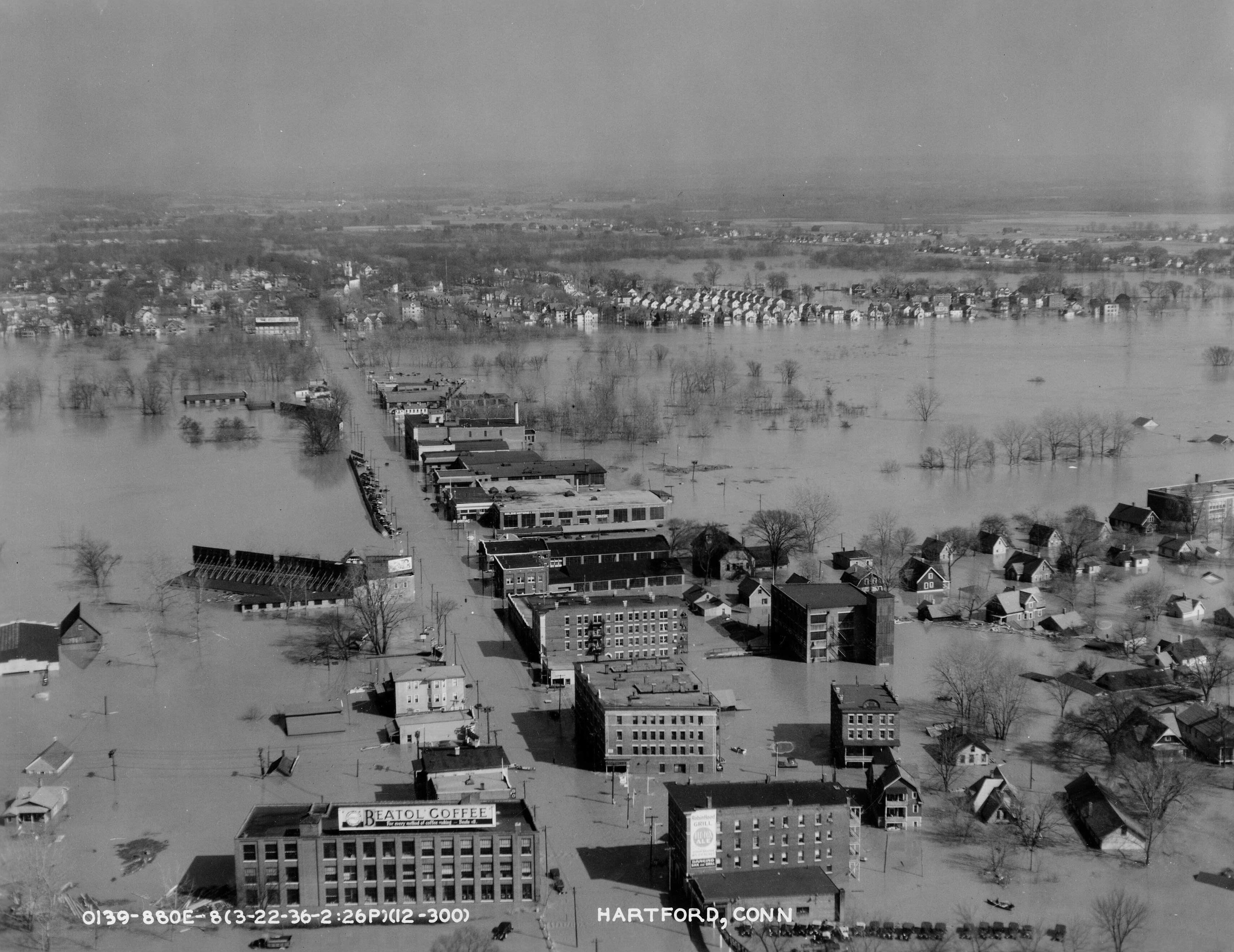
Hartford during the March 1936 flood, aerial view
Hartford during the March 1936 flood, aerial view — March 22, 1936
Image credit & source
U.S. War Department; National Archives and Records Administration / Wikimedia Commons
Public domain; U.S. federal government photograph. Cropped version supplied on Wikimedia Commons.
Original source · Reuse terms
1936
Connecticut River flooding near Hartford
Connecticut River flooding near Hartford
Image credit & source
John F. Dreier / Wikimedia Commons
CC BY-SA 3.0; unaltered source scan.
Original source · Reuse terms
1936
Floodwater surrounding downtown buildings
Flooded Hartford street with a partially submerged hydrant, parking signs and commercial buildings.
Image credit & source
John F. Dreier / Wikimedia Commons
CC BY-SA 3.0, released by the photographer’s grandson and holder of the original negative; unaltered source scan.
Original source · Reuse terms
1936
Downtown storefronts during the flood
Water covers the street outside the Electric House storefront; a truck stands at the right.
Image credit & source
John F. Dreier / Wikimedia Commons
CC BY-SA 3.0, released by the photographer’s grandson and holder of the original negative; unaltered source scan.
Original source · Reuse terms
1936
A rowboat on a flooded Hartford street
A man rows between downtown buildings in floodwater, Hartford, 1936.
Image credit & source
John F. Dreier / Wikimedia Commons
CC BY-SA 3.0, released by the photographer’s grandson and holder of the original negative; unaltered source scan.
Original source · Reuse terms
1936
Sandbags at the Hotel Bond entrance
People stand at the Hotel Bond entrance behind sandbags while floodwater covers the street.
Image credit & source
John F. Dreier / Wikimedia Commons
CC BY-SA 3.0, released by the photographer’s grandson and holder of the original negative; unaltered source scan.
Original source · Reuse terms
THE STORY BEHIND THE PHOTOGRAPHS
People, places, and change.
A regional storm becomes a local disaster
The flood of March 1936 was part of a much larger New England emergency. Heavy precipitation and melting snow combined with winter ice to overwhelm river systems. The U.S. Geological Survey recorded two major flood peaks in many basins and emphasized the damage caused by breaking ice. At Hartford the Connecticut River reached 37.6 feet, the record crest listed by the National Weather Service. This was not simply a flooded street: it was an entire river basin delivering water through a densely developed city. [1] [2]
Seeing the city from two levels
John F. Dreier’s photograph shows the Connecticut River flooding near Hartford in 1936. A federal aerial view dated March 22 supplies a different kind of evidence, revealing the relationship between the river, industrial districts and surrounding neighborhoods. Neither viewpoint tells the whole story. A ground-level image records water against the familiar landscape; an aerial survey makes the extent of inundation legible. Used together, they help explain the scale of the emergency. [6] [5]
![[5]](https://commons.wikimedia.org/wiki/File:Connecticut_-_Hartford_-_NARA_-_23936427_(cropped).jpg)
From emergency to permanent infrastructure
The Army Corps of Engineers describes a protection system of dikes, walls, conduits and pumping stations built to shelter Hartford’s developed land. Most of the original works began in December 1938 and were completed in August 1944. The Park River conduit carried water beneath the central city and Bushnell Park toward the Connecticut River. A once-visible river became part of an underground infrastructure network. Flood protection thus altered ordinary urban space, not only the city’s response to exceptional storms. [3]
An engineering story extending beyond the 1930s
The work continued after the first construction campaign. The Folly Brook conduit was built in 1956–1957, and a Park River auxiliary conduit and two pumping stations followed in 1976–1981. These dates show a changing assessment of risk and capacity across decades. The photographs preserve what the flood looked like; engineering records explain how officials responded. Keeping both forms of evidence together makes it possible to study protection, buried waterways and the costs of living beside a major river. [3]
Reading the street photographs
Four additional John F. Dreier photographs bring the flood down to the scale of individual buildings. Commercial signs remain above water outside downtown garages and shops; another frame shows a man using a rowboat between buildings. At the Hotel Bond, people stand behind a line of sandbags at the entrance. These are details visible in the photographs. They show disrupted access and improvised protection without establishing when each frame was made within the flood or what happened to every person pictured. [7] [8] [9] [10]
Sources & further reading (10)
- U.S. Geological Survey: The floods of March 1936
- National Weather Service: Historic Flood March 1936
- U.S. Army Corps of Engineers: Hartford Local Protection Project
- John F. Dreier: Downtown Hartford flood photograph, 1936
- National Archives: Hartford aerial survey, March 22, 1936
- John F. Dreier: Connecticut River flooding near Hartford, 1936
- Floodwater surrounding downtown buildings — John F. Dreier, 1936
- Downtown storefronts during the flood — John F. Dreier, 1936
- A rowboat on a flooded Hartford street — John F. Dreier, 1936
- Sandbags at the Hotel Bond entrance — John F. Dreier, 1936
Keep the sources close.
Download this collection’s notes, timeline and image credits. Photographs link to their original archives and require an internet connection.
Building dates and photograph dates are recorded separately. Later photographs are identified in their captions; unknown exposure dates remain unknown. Follow each image’s credit and reuse terms.