
New London COUNTY · Maritime industry
State Pier: Rails, Cargo, and New London’s Working Waterfront
Follow a state-financed harbor project from its 1914 construction to a richly photographed working waterfront in April 1993.
Historical focus · 1909–1995
LOOK CLOSER · OPEN ANY IMAGE
The story in photographs
April 1993
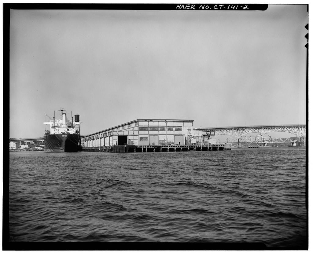
View north, general view from water
View north, general view from water — Connecticut State Pier, State Pier Road at Thames River, New London, New London County, CT
Image credit & source
Robert Moore; Library of Congress, Prints and Photographs Division, HABS/HAER.
No known restrictions on images made by the U.S. Government; images copied from other sources may be restricted.
Original source · Reuse termsApril 1993
View southwest, general view from land, with ship Odigitria B docked along west side
View southwest, general view from land, with ship Odigitria B docked along west side — Connecticut State Pier, State Pier Road at Thames River, New London, New London County, CT
Image credit & source
Robert Moore; Library of Congress, Prints and Photographs Division, HABS/HAER.
No known restrictions on images made by the U.S. Government; images copied from other sources may be restricted.
Original source · Reuse termsApril 1993
View east, general view showing west side with no ship docked
View east, general view showing west side with no ship docked. — Connecticut State Pier, State Pier Road at Thames River, New London, New London County, CT
Image credit & source
Robert Moore; Library of Congress, Prints and Photographs Division, HABS/HAER.
No known restrictions on images made by the U.S. Government; images copied from other sources may be restricted.
Original source · Reuse termsApril 1993
View southeast, end view of main warehouse, land side
View southeast, end view of main warehouse, land side — Connecticut State Pier, State Pier Road at Thames River, New London, New London County, CT
Image credit & source
Robert Moore; Library of Congress, Prints and Photographs Division, HABS/HAER.
No known restrictions on images made by the U.S. Government; images copied from other sources may be restricted.
Original source · Reuse termsApril 1993
View southeast, showing west side from land, with waste paper bundled on dock, awaiting loading onto Odigitria B
View southeast, showing west side from land, with waste paper bundled on dock, awaiting loading onto Odigitria B — Connecticut State Pier, State Pier Road at Thames River, New London, New London County, CT
Image credit & source
Robert Moore; Library of Congress, Prints and Photographs Division, HABS/HAER.
No known restrictions on images made by the U.S. Government; images copied from other sources may be restricted.
Original source · Reuse termsApril 1993
View northwest, showing west side toward land, with Odigitria B docked alongside
View northwest, showing west side toward land, with Odigitria B docked alongside — Connecticut State Pier, State Pier Road at Thames River, New London, New London County, CT
Image credit & source
Robert Moore; Library of Congress, Prints and Photographs Division, HABS/HAER.
No known restrictions on images made by the U.S. Government; images copied from other sources may be restricted.
Original source · Reuse termsApril 1993
View south, detail of north end of main warehouse, showing truck and rail entrances
View south, detail of north end of main warehouse, showing truck and rail entrances — Connecticut State Pier, State Pier Road at Thames River, New London, New London County, CT
Image credit & source
Robert Moore; Library of Congress, Prints and Photographs Division, HABS/HAER.
No known restrictions on images made by the U.S. Government; images copied from other sources may be restricted.
Original source · Reuse termsApril 1993
Detail of typical section of wood deck and piling
Detail of typical section of wood deck and piling — Connecticut State Pier, State Pier Road at Thames River, New London, New London County, CT
Image credit & source
Robert Moore; Library of Congress, Prints and Photographs Division, HABS/HAER.
No known restrictions on images made by the U.S. Government; images copied from other sources may be restricted.
Original source · Reuse termsApril 1993
Detail of typical mooring post
Detail of typical mooring post — Connecticut State Pier, State Pier Road at Thames River, New London, New London County, CT
Image credit & source
Robert Moore; Library of Congress, Prints and Photographs Division, HABS/HAER.
No known restrictions on images made by the U.S. Government; images copied from other sources may be restricted.
Original source · Reuse termsApril 1993
View south, water tower at north end of pier
View south, water tower at north end of pier — Connecticut State Pier, State Pier Road at Thames River, New London, New London County, CT
Image credit & source
Robert Moore; Library of Congress, Prints and Photographs Division, HABS/HAER.
No known restrictions on images made by the U.S. Government; images copied from other sources may be restricted.
Original source · Reuse termsApril 1993
Interior, showing lower level of main warehouse, rails on right
Interior, showing lower level of main warehouse, rails on right — Connecticut State Pier, State Pier Road at Thames River, New London, New London County, CT
Image credit & source
Robert Moore; Library of Congress, Prints and Photographs Division, HABS/HAER.
No known restrictions on images made by the U.S. Government; images copied from other sources may be restricted.
Original source · Reuse termsApril 1993
Interior, one-story side wing, showing roof trusses
Interior, one-story side wing, showing roof trusses — Connecticut State Pier, State Pier Road at Thames River, New London, New London County, CT
Image credit & source
Robert Moore; Library of Congress, Prints and Photographs Division, HABS/HAER.
No known restrictions on images made by the U.S. Government; images copied from other sources may be restricted.
Original source · Reuse termsTHE STORY BEHIND THE PHOTOGRAPHS
People, places, and change.
A public investment in the harbor
New London’s State Pier began as an ambitious attempt to connect ocean shipping with an inland railroad network. A state study commission formed in 1909, with Mayor Bryan F. Mahan among the project’s advocates. In 1911 the legislature established a permanent commission and authorized a million dollars for the work. The planners expected the Central Vermont Railroad’s connections with Canada and the Midwest to attract cargo through New London. Their scheme joined harbor depth, rail access, and a large covered transfer space in one public facility. [2]
Building a place for cargo
Engineers Waldo E. Clarke and William T. Donnelly designed the pier, which the T. A. Scott Company completed in 1914. Its long central section combined fill and masonry with timber piling around the edges. A large wood-framed warehouse, completed in April 1917, occupied most of the deck. Railroad tracks entered the building so that goods could move between vessels, freight cars, and storage under cover. The survey records the pier’s length as 1,020 feet and the warehouse’s plan as 822 by 183 feet: an industrial landscape organized around the movement of bulky cargo. [2]
Commercial hopes and wartime service
The pier’s economic history was uneven. Traffic after the First World War initially encouraged the project’s supporters, but competition from Canadian ports helped undermine its original commercial expectations. By the mid-1920s the early optimism had faded. Military use was an important part of its history: the United States Navy used the facility during both world wars, and naval occupancy continued into the postwar period. The engineering survey therefore treats the pier both as an economic-development experiment and as infrastructure whose usefulness extended beyond its promoters’ first business plan. [2]
A waterfront photographed in 1993
Robert Moore’s April 1993 photographs show the ship Odigitria B alongside the pier, bundles of wastepaper, truck and railroad entrances, a pallet-truck scale, and the warehouse interior. They also record mooring fittings, deck edges, and the wooden structure beneath the surface. These details connect the monumental size of the building with the smaller equipment that made everyday cargo handling possible. The accompanying report anticipated substantial rebuilding in 1995; the photographs preserve the older facility before that proposed work. They are period documentation, not images of the waterfront’s present arrangement. [3] [2]
Keep the sources close.
Download this collection’s notes, timeline and image credits. Photographs link to their original archives and require an internet connection.
Building dates and photograph dates are recorded separately. Later photographs are identified in their captions; unknown exposure dates remain unknown. Follow each image’s credit and reuse terms.