
New London COUNTY · Coastal communities
Wilcox Road: Fishing Families, Shore Houses, and the Railroad
Eight photographs from April 1997 explore a coastal district shaped by menhaden fishing, family houses, an old cemetery, and the shoreline railroad.
Historical focus · 1858–1997
LOOK CLOSER · OPEN ANY IMAGE
The story in photographs
April 1997
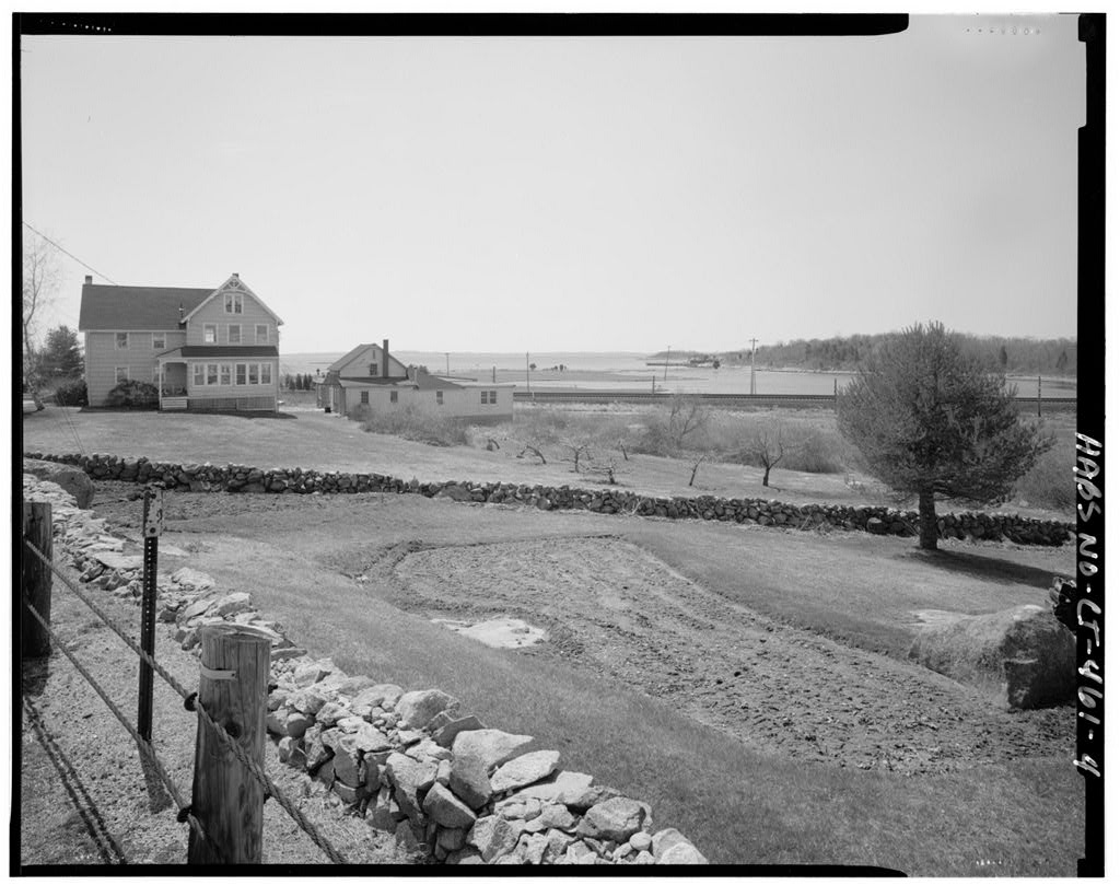
View from Wilcox Road, looking southwest over railroad tracks towards Latimer Point
View from Wilcox Road, looking southwest over railroad tracks towards Latimer Point — Wilcox Road Historic District, Wilcox Road, Stonington, New London County, CT
Image credit & source
Robert Brewster, Warren Jagger Photography; Library of Congress, Prints and Photographs Division, HABS/HAER.
No known restrictions on images made by the U.S. Government; images copied from other sources may be restricted.
Original source · Reuse termsApril 1997
View from north end of Latimer Point, looking northeast towards Wilcox Road Historic District
View from north end of Latimer Point, looking northeast towards Wilcox Road Historic District — Wilcox Road Historic District, Wilcox Road, Stonington, New London County, CT
Image credit & source
Robert Brewster, Warren Jagger Photography; Library of Congress, Prints and Photographs Division, HABS/HAER.
No known restrictions on images made by the U.S. Government; images copied from other sources may be restricted.
Original source · Reuse termsApril 1997
View from Amtrak Railroad tracks, looking east along tracks towards Wilcox Road Historic District
View from Amtrak Railroad tracks, looking east along tracks towards Wilcox Road Historic District — Wilcox Road Historic District, Wilcox Road, Stonington, New London County, CT
Image credit & source
Robert Brewster, Warren Jagger Photography; Library of Congress, Prints and Photographs Division, HABS/HAER.
No known restrictions on images made by the U.S. Government; images copied from other sources may be restricted.
Original source · Reuse termsApril 1997
View from intersection of U.S. Route 1 and Wilcox Road, looking south towards railroad tracks and Fisher Island Sound
View from intersection of U.S. Route 1 and Wilcox Road, looking south towards railroad tracks and Fisher Island Sound — Wilcox Road Historic District, Wilcox Road, Stonington, New London County, CT
Image credit & source
Robert Brewster, Warren Jagger Photography; Library of Congress, Prints and Photographs Division, HABS/HAER.
No known restrictions on images made by the U.S. Government; images copied from other sources may be restricted.
Original source · Reuse termsApril 1997
View from beach, looking southwest over railroad tracks towards Latimer Point
View from beach, looking southwest over railroad tracks towards Latimer Point — Wilcox Road Historic District, Wilcox Road, Stonington, New London County, CT
Image credit & source
Robert Brewster, Warren Jagger Photography; Library of Congress, Prints and Photographs Division, HABS/HAER.
No known restrictions on images made by the U.S. Government; images copied from other sources may be restricted.
Original source · Reuse termsApril 1997
View from U.S. Route 1 bridge over Quiambog Cove, looking southwest towards Miner Cemetery, Wilcox Road Historic…
View from U.S. Route 1 bridge over Quiambog Cove, looking southwest towards Miner Cemetery, Wilcox Road Historic District — Wilcox Road Historic District, Wilcox Road, Stonington, New London County, CT
Image credit & source
Robert Brewster, Warren Jagger Photography; Library of Congress, Prints and Photographs Division, HABS/HAER.
No known restrictions on images made by the U.S. Government; images copied from other sources may be restricted.
Original source · Reuse termsApril 1997
View from U.S. Route 1, looking southwest over Quiambog Cove towards Wilcox Road Historic District
View from U.S. Route 1, looking southwest over Quiambog Cove towards Wilcox Road Historic District — Wilcox Road Historic District, Wilcox Road, Stonington, New London County, CT
Image credit & source
Robert Brewster, Warren Jagger Photography; Library of Congress, Prints and Photographs Division, HABS/HAER.
No known restrictions on images made by the U.S. Government; images copied from other sources may be restricted.
Original source · Reuse termsApril 1997
View from Amtrak Railroad overpass at Noyes Avenue, looking west towards Wilcox Road Historic District
View from Amtrak Railroad overpass at Noyes Avenue, looking west towards Wilcox Road Historic District — Wilcox Road Historic District, Wilcox Road, Stonington, New London County, CT
Image credit & source
Robert Brewster, Warren Jagger Photography; Library of Congress, Prints and Photographs Division, HABS/HAER.
No known restrictions on images made by the U.S. Government; images copied from other sources may be restricted.
Original source · Reuse termsTHE STORY BEHIND THE PHOTOGRAPHS
People, places, and change.
A neighborhood between water and rail
The Wilcox Road district lies between Mystic and Stonington around the low-lying shore of Quiambaug Neck. Coves and open water shape its setting, while the railroad crosses the southern part of the district. The line’s extension from Stonington toward Groton in 1858 brought a new transportation corridor through the marsh landscape. The historical survey records a group of houses and other buildings, many dating from the late nineteenth and early twentieth centuries. It also includes the older Miner Cemetery, a reminder that the neighborhood’s layers extend beyond the industrial period emphasized here. [2]
Menhaden and the Wilcox family
Members of the Wilcox family worked as fishermen and coastal mariners before developing enterprises based on menhaden. The fish supplied oil used in products such as lubricants and paint, while the remaining material could be sold as fertilizer. Elnathan Wilcox operated a factory near Quiambaug before a fire in 1865. A new enterprise with Elias Wilcox followed at Latimer Point in 1866. The district’s domestic history was therefore connected with industrial work on nearby waterfront sites, even where the factories themselves were no longer standing when the federal survey was prepared. [2]
Houses and changing livelihoods
The report connects particular houses with members of the family, including Elias Wilcox’s 1874 house and later dwellings built as other family households formed. Different roof forms, porches, and additions preserve evidence of successive generations rather than a single planned development. The fertilizer business closed in 1935 as competing products changed its market. In 1937 George Wilcox converted a barn and garage into a boat showroom. That small change in use illustrates a broader theme in coastal history: families adapted existing land and buildings as the sources of their livelihood shifted. [2]
A landscape recorded before new wires
Robert Brewster of Warren Jagger Photography made the selected photographs in April 1997. Federal documentation addressed the effects of the Northeast Corridor electrification project, including the introduction of overhead electrical infrastructure along the railroad. The images therefore emphasize relationships between houses, roads, marshes, shoreline, cemetery, and tracks. Their wider views are especially valuable because a historic neighborhood is more than a list of individual buildings. These photographs preserve the spaces and sightlines between its components at a particular moment, showing how domestic, industrial, transportation, and burial landscapes occupied the same small coastal area. [3] [2]
Keep the sources close.
Download this collection’s notes, timeline and image credits. Photographs link to their original archives and require an internet connection.
Building dates and photograph dates are recorded separately. Later photographs are identified in their captions; unknown exposure dates remain unknown. Follow each image’s credit and reuse terms.