
ED087-S01 · Sources & research leads · See individual source date
West Haven: Tour 5, North Allingtown
Horseshoe Lagoon
PDF p7: lagoon location, mixed water sources and remembered recreational uses.
Read item & source notesCOLLECTION 087 · SGC-ED087
West Haven · New Haven · Parks & historic lands
Excavation, recreation, drainage and restoration beside Marginal Drive.
Dates distinguish founding, building opening and later changes; see the chronology below.
LOOK CLOSER · OPEN ANY IMAGE
2021-09-13
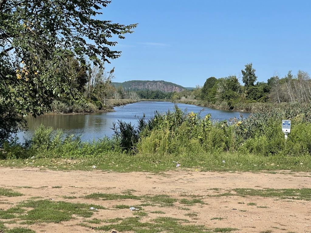
North toward West Rock along memorial canal. West River Memorial Park context, photographed September 13, 2021.
2021-09-13
North at the gated end of Marginal Drive. West River Memorial Park context, photographed September 13, 2021.
2021-09-13
South along Marginal Drive. West River Memorial Park context, photographed September 13, 2021.
2021-09-13
World War I memorial near Barnard Nature Center. West River Memorial Park context, photographed September 13, 2021.
2021-09-13
Southwest from near Barnard Science Center. West River Memorial Park context, photographed September 13, 2021.
2021-09-13
Trees along Ella T. Grasso Boulevard. West River Memorial Park context, photographed September 13, 2021.
COLLECTION HISTORY
Horseshoe Lagoon lies west of Marginal Drive and the West River, south of St. Lawrence Cemetery in West Haven. It belongs to the landscape of West River Memorial Park, whose history crosses the municipal boundary with New Haven. The city’s North Allingtown tour describes freshwater runoff mixing with river water and recalls swimming, fishing and skating. This is the lagoon beside the drive, not an amusement-park ride at Savin Rock. [ED087-S01] [ED087-S02]
The wider park emerged through an Olmsted planning process. A 1924 plan survives in the state’s landscape survey. David Casagrande’s researched chronology dates excavation south of St. Lawrence Cemetery to 1926, using material for roadway and island fill, and places completion of Marginal Drive in 1927. These are secondary historical findings grounded in municipal reports; the original reports remain a priority for checking the construction sequence. The later asphalt paving date is a different event from creating the drive. [ED087-S02] [ED087-S03]
Recreation gave the water another role. The Yale educational guide and the municipal tour describe swimming instruction, facilities and other uses. Casagrande’s chronology records swimming facilities in 1944 and later drownings, including two boys in 1964, followed by incomplete attempts to fill the lagoon. These events are treated as part of a documented public-safety and land-use history, without inventing names or extending wider park attendance totals to the lagoon alone. [ED087-S01] [ED087-S03] [ED087-S04]
By 1982 the city’s coastal program evaluated the area through wetlands, flooding, open space and transport. Later records make the drainage connections especially concrete. A Coast Guard determination concerning a November 2009 spill describes oil entering storm drains and reaching the lagoon. That administrative record connects an urban street incident with a waterbody that might otherwise appear separate from surrounding development. Its redactions and internal date discrepancies should be preserved. [ED087-S05] [ED087-S06]
The 2015 watershed assessment describes freshwater drainage, tidal restrictions and the 2012 replacement of three tide gates. The management plan recommends further evaluation and monitoring; recommendations do not establish completed restoration. A 1997 Yale announcement and later reporting on Marginal Drive show recurring community attention. Together these sources make the lagoon a story of design, recreation, altered water flows and stewardship, rather than simply a forgotten scenic place. [ED087-S07] [ED087-S08] [ED087-S09]
The photographs in this edition distinguish actual lagoon views from the wider park context. The 2021 survey photographs show the memorial canal, drive, gates and memorial features; they are not all photographs of Horseshoe Lagoon itself. Original park reports, dated swimming-area photographs and a fuller record of maintenance decisions remain the strongest next sources for expanding the story. [ED087-S02] [ED087-S07]
Dates distinguish founding, building opening and later changes; see the chronology below.
THE SEARCHABLE CATALOG
Search includes catalog notes and the OCR text included with this edition. OCR may misread names or dates; use the original scan to verify a match.
ED087-S01 · Sources & research leads · See individual source date
Horseshoe Lagoon
PDF p7: lagoon location, mixed water sources and remembered recreational uses.
Read item & source notesED087-S02 · Sources & research leads · See individual source date
Horseshoe Lagoon
2021 inventory, 1924 plan and six individually captioned park-context photographs.
Read item & source notesED087-S03 · Sources & research leads · See individual source date
Horseshoe Lagoon
Scholarly secondary chronology based on municipal sources; dates not independently verified in original annual reports.
Read item & source notesED087-S04 · Sources & research leads · See individual source date
Horseshoe Lagoon
Park unit, printed pp37–39: lagoon and park learning activities.
Read item & source notesED087-S05 · Sources & research leads · See individual source date
Horseshoe Lagoon
Coastal Planning Area 9; repository labels publication public domain.
Read item & source notesED087-S06 · Sources & research leads · See individual source date
Horseshoe Lagoon
November 2009 spill and drainage connection; keep redactions and source date discrepancies.
Read item & source notesED087-S07 · Sources & research leads · See individual source date
Horseshoe Lagoon
Drainage, historical aerial comparisons and 2012 tide-gate replacement.
Read item & source notesED087-S08 · Sources & research leads · See individual source date
Horseshoe Lagoon
Recommendations and monitoring priorities, not proof of completed work.
Read item & source notesED087-S09 · Sources & research leads · See individual source date
Horseshoe Lagoon
Contemporary announcement identifies Horseshoe Lagoon as a cleanup location.
Read item & source notesED-PARK-L02 · Photographs · 2021-09-13
Horseshoe Lagoon
North toward West Rock along memorial canal. West River Memorial Park context, photographed September 13, 2021.
Read item & source notes
ED-PARK-L03 · Photographs · 2021-09-13
Horseshoe Lagoon
North at the gated end of Marginal Drive. West River Memorial Park context, photographed September 13, 2021.
Read item & source notes
ED-PARK-L04 · Photographs · 2021-09-13
Horseshoe Lagoon
South along Marginal Drive. West River Memorial Park context, photographed September 13, 2021.
Read item & source notes
ED-PARK-L05 · Photographs · 2021-09-13
Horseshoe Lagoon
World War I memorial near Barnard Nature Center. West River Memorial Park context, photographed September 13, 2021.
Read item & source notes
ED-PARK-L06 · Photographs · 2021-09-13
Horseshoe Lagoon
Southwest from near Barnard Science Center. West River Memorial Park context, photographed September 13, 2021.
Read item & source notes
ED-PARK-L07 · Photographs · 2021-09-13
Horseshoe Lagoon
Trees along Ella T. Grasso Boulevard. West River Memorial Park context, photographed September 13, 2021.
Read item & source notesExtract the ZIP and open START_HERE.html. It includes the catalog, selected images, acquired source text, credits and a searchable SQLite database. New photo additions are hosted in the SGC media library and require an internet connection; original bundled images remain available offline.