
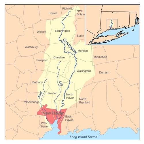
Regional map distinguishing the West, Mill and Quinnipiac rivers and surrounding municipalities. Useful for understanding the river setting; insufficient for parcel or road-boundary determinations.
Evidence, credit & reuse: CC BY-SA 2.5; credit and share-alike license must accompany reuse. Original retrieved PNG is 500 × 500, matching the source dimensions; retained. Display JPEG conversion only, no map edits or upscaling. Watershed boundaries are approximate; municipal geography findings rely on additional sources.
Source: Karl Musser (Kmusser), via Wikimedia Commons
Searchable text & research notes
Included OCR or searchable notes appear below and in the download. Use your browser’s Find command to search this page. OCR errors and historical language are retained.
Read the included text
New Haven region rivers and approximate watersheds
Date: 2007-01-18 (upload date)
Regional map distinguishing the West, Mill and Quinnipiac rivers and surrounding municipalities. Useful for understanding the river setting; insufficient for parcel or road-boundary determinations.
Source: https://commons.wikimedia.org/wiki/File:Newhavenrivers.png
Credit: Karl Musser (Kmusser), via Wikimedia Commons
Rights: CC BY-SA 2.5; credit and share-alike license must accompany reuse.
License: https://creativecommons.org/licenses/by-sa/2.5/
Notes: Original retrieved PNG is 500 × 500, matching the source dimensions; retained. Display JPEG conversion only, no map edits or upscaling. Watershed boundaries are approximate; municipal geography findings rely on additional sources.
Cite this item
Silent Grounds Collective, Marginal Drive and the West River landscape, SGC-MDR-026, MDR-004, “New Haven region rivers and approximate watersheds.” Source: Karl Musser (Kmusser), via Wikimedia Commons. https://commons.wikimedia.org/wiki/File:Newhavenrivers.png. Research edition, accessed 2026-09-08.