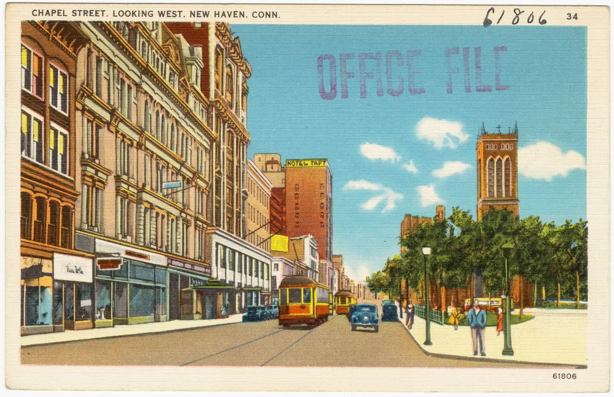
Chapel Street looking west, New Haven · Circa 1930–1945, catalog range
OPENING / FIRST RECORDED DATE1861 — horsecar service · 1892 — electric service
FOUNDED / HISTORICAL PERIODHorsecar era from 1861; electric era from 1892
Horse-drawn service preceded electric trolleys by three decades. These dates describe the New Haven network; individual West Haven and shore branches opened at different times. The included maps begin in 1902.
LOOK CLOSER · OPEN ANY IMAGE
The story in photographs
17 images
July 21, 1968
Open car 1425 at the Branford trolley museum
Roger Puta photographed the former New Haven Connecticut Company open car at the museum in East Haven. This is a preservation-era photograph, not an image of regular street service.
Car 303 at the Seashore Trolley Museum in Maine. The museum traces this car to the Winchester Avenue Railroad in New Haven in 1901. Its present location is different from its original operating city.
Image credit & source
Elizabeth K. Joseph from San Francisco, United States; CC BY 2.0; Wikimedia Commons
A later museum view of the preserved Connecticut Company open car. Its benches recall the form of vehicles used for New Haven passenger service and football crowds.
A view from preserved car 303 at the Seashore Trolley Museum. This image makes the experience of an open car visible while retaining its modern museum date.
This wartime industrial scene shows street railways amid the everyday movements of factory workers. The identified intersection grounds the image in New Haven.
Image credit & source
Lt. Lentz, SIG.R.C.; War Department, Army War College, Historical Section, World War I Branch; National Archives, Record Group 111
The 1904 guide’s map places Savin Rock and New Haven within a wider network of trolley excursions.
Image credit & source
Cromwell Childe, author; Brooklyn Daily Eagle, publisher; map artist not separately identified; Columbia University Libraries; digitized by Internet Archive with support from The Durst Organization
Read the full story of New Haven & West Haven Trolleys
COLLECTION HISTORY
The people behind the place.
Before wires hung over the streets, horses pulled New Haven’s streetcars. Service began in 1861, connecting neighborhoods through the city center. Electric operation arrived in 1892 and transformed the speed and reach of everyday travel. The last New Haven streetcar lines gave way to buses on September 25, 1948; preserved cars now let visitors see the vehicles beyond the maps and timetables. [TR-HISTORY-2026]
The maps reveal a network rather than one line with one founding day. A 1902 New Haven map connects the city with West Haven, Savin Rock and Woodmont, while later statewide maps show a broader system of lines and connections. Any later museum highlighting on the 1902 reproduction is distinguished from its original printing. [TR-001]
Cromwell Childe’s 1904 guide gives readers a journey from Bridgeport through Stratford, Milford, Woodmont and Savin Rock to New Haven. Its Route 46 describes 22 miles, two hours and a 25-cent fare. These are contemporary guidebook claims, and its numbered itineraries should not be mistaken for official line numbers. [TR-011]
The Winchester photograph shows a streetcar among workers at noon on April 6, 1918. Shoreline postcards present a different setting: waiting stations and leisure destinations. Together the sources connect everyday city movement with recreational travel, while preserving the difference between a federal photograph and a promotional postcard. [TR-006]
The Shore Line Trolley Museum preserves part of the former Branford line. Its history dates commercial service on that line from July 31, 1900 to March 8, 1947, followed by museum operation. This date range belongs to the Branford route; the final New Haven city services require separate contemporary confirmation. [TR-013]
A streetcar amid factory workers and a waiting station at a seaside resort reveal different journeys within a connected system. The network carried people toward employment and entertainment, but a map alone cannot tell how often a particular person traveled or how crowded a car was. The 1904 guide’s fare and travel-time statements are contemporary claims for a described itinerary. They should not become universal prices or official route numbers. Likewise, the Branford line’s final commercial-service date belongs to that line. Reading maps, photographs and guidebooks together makes transportation a regional story while preserving the exact limits of each route and source. [TR-001] [TR-011] [TR-006]
ESTABLISHEDHorsecar era from 1861; electric era from 1892
EARLIEST HISTORY1861 — horsecar service · 1892 — electric service
Horse-drawn service preceded electric trolleys by three decades. These dates describe the New Haven network; individual West Haven and shore branches opened at different times. The included maps begin in 1902.
About this research edition. Twelve included images: five maps, four postcards, one 1918 photograph and two route-guide pages. Neighboring East Haven and Branford material is explicitly identified as connecting-route context. Route 46 and Route 47 are the guidebook’s itinerary numbers, not verified transit operator line numbers. Maps have different dates and geographic coverage; no complete timetable or route register has been acquired.
THE SEARCHABLE CATALOG
Images, maps & original records
Search includes catalog notes and the OCR text included with this edition. OCR may misread names or dates; use the original scan to verify a match.
23-page scan. PDF pages 6–7 contain historical significance; pages 3–5 contain equipment rosters. Photograph credits include private photographers, so the PDF’s photographs were not treated as blanket public-domain image assets. Read visually: no usable text layer.
Cromwell Childe, Brooklyn Daily Eagle, 1904. Columbia University Libraries. Pages 68, 75 and 76 included. Contains further route descriptions and boat connections; route headings are editorial itinerary numbers.
BPL 06_10_004272; Tichnor 61806. Item metadata and reusable scan verified through Commons; direct Digital Commonwealth endpoint returned 403 in this pass.
Secondary account gives September 25, 1948 and cites Hartford Courant, September 26, 1948, “Trolley Cars Run No More in New Haven.” Original newspaper page not obtained here. Another overview uses September 26; confirm actual last-run calendar date before publishing an exact day.
The regional streetcar assessment traces New Haven horsecar service to 1861, electrification to 1892, and the end of city streetcar service to September 25, 1948.
Roger Puta photographed the former New Haven Connecticut Company open car at the museum in East Haven. This is a preservation-era photograph, not an image of regular street service.
Car 303 at the Seashore Trolley Museum in Maine. The museum traces this car to the Winchester Avenue Railroad in New Haven in 1901. Its present location is different from its original operating city.
A later museum view of the preserved Connecticut Company open car. Its benches recall the form of vehicles used for New Haven passenger service and football crowds.
A view from preserved car 303 at the Seashore Trolley Museum. This image makes the experience of an open car visible while retaining its modern museum date.
Extract the ZIP and open START_HERE.html. It includes the catalog, selected images, acquired source text, credits and a searchable SQLite database. New photo additions are hosted in the SGC media library and require an internet connection; original bundled images remain available offline.



_1425_open_car_at_Brandford_Trolley_Museum,_East_Haven,_CT_July_21,_1968_(25366724334).jpg)


.jpg)
